


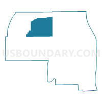
Voting District 070002, Yates County, New York
About
Outline

Summary
| Unique Area Identifier | 639197 |
| Name | Voting District 070002 |
| County | Yates County |
| State | New York |
| Area (square miles) | 27.89 |
| Land Area (square miles) | 27.89 |
| Water Area (square miles) | 0.00 |
| % of Land Area | 100.00 |
| % of Water Area | 0.00 |
| Latitude of the Internal Point | 42.70231370 |
| Longtitude of the Internal Point | -77.17964020 |
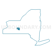
Maps

Graphs
Select a template below for downloading or customizing gragh for Voting District 070002, Yates County, New York


Neighbors
Neighoring Voting District (by Name) Neighboring Voting District on the Map
- Voting District 020001, Yates County, NY
- Voting District 020002, Yates County, NY
- Voting District 030001, Yates County, NY
- Voting District 040003, Yates County, NY
- Voting District 040004, Yates County, NY
- Voting District 050001, Yates County, NY
- Voting District 070001, Yates County, NY
Top 10 Neighboring County Subdivision (by Population) Neighboring County Subdivision on the Map
- Jerusalem town, Yates County, NY (4,469)
- Benton town, Yates County, NY (2,836)
- Potter town, Yates County, NY (1,865)
- Middlesex town, Yates County, NY (1,495)
- Italy town, Yates County, NY (1,141)
Top 10 Neighboring Unified School District (by Population) Neighboring Unified School District on the Map
Top 10 Neighboring State Legislative District Lower Chamber (by Population) Neighboring State Legislative District Lower Chamber on the Map
Top 10 Neighboring State Legislative District Upper Chamber (by Population) Neighboring State Legislative District Upper Chamber on the Map
Top 10 Neighboring 111th Congressional District (by Population) Neighboring 111th Congressional District on the Map
Top 10 Neighboring Census Tract (by Population) Neighboring Census Tract on the Map
- Census Tract 1502, Yates County, NY (5,561)
- Census Tract 1503, Yates County, NY (5,348)
- Census Tract 1504, Yates County, NY (3,973)